
Some of the numbers presented in this website may not be the most recent available
globalshift.co.uk - copyright © 2009 to 2026; All rights reserved


Brief history of the country
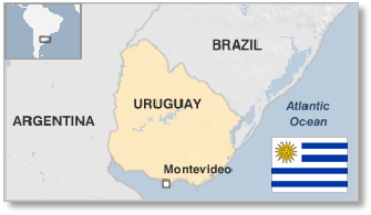
Uruguay (the Eastern Republic of Uruguay) is bordered by Argentina to the west and Brazil to the northeast. Southeast is the Atlantic Ocean. The estuary of the Uruguay River forms the southwestern border.
Uruguay was inhabited by the Charrúa people for 4000 years before Portugal discovered it in 1512, with Spain arriving in 1516. The first permanent Spanish settlement was founded in 1624.
The Portuguese built a fort at Sacramento in 1699 and Spain then turned Montevideo into a military stronghold from 1723 to compete with Buenos Aires. It was briefly occupied by the UK in 1807. From 1811 the country fought for independence from Spain and Portugal.
Finally in 1828 the Treaty of Montevideo, fostered by the UK, created Uruguay as an independent state. However, it remained subject to intervention by Argentina, Brazil and Paraguay throughout the 19th century followed by military governments which had a dominant role until 1984, when democracy returned.
Uruguay is now relatively wealthy and socially developed. It exports wool, rice, soybeans, beef, malt and milk.
Oil and gas summary
Uruguay comprises mostly plains and low hills with a coastal lowland covered by a network of rivers. The highest point is the Cerro Catedral at just 514m. Offshore an extensive shelf region dips into the Atlantic Ocean.
There are a number of sedimentary basins in the country but drilling up to now has failed to locate any commercial fields and Uruguay has no identified indigenous oil or gas resources. Its offshore area lies adjacent to the prolific Brazilian Santos Basin and it has thus seen interest in its deep water prospects in recent years.
There are now regular efforts by the government to market the 15 or so offshore blocks designated, overlying the shallow and deep water Oriental del Plata, Punta del Este and Pelotas Basins. Onshore unconventional shale targets are also being explored in the hope of reservoirs matching the Bakken in the USA.
In 2012 a number of large companies were awarded exploration licences in 8 of these blocks but there is still insufficient evidence of prospects to assign an oil production profile to the country and Globalshift forecasts no oil or gas production, onshore or offshore, at least in the short and medium term.
URUGUAY
Map and National Flag

SOUTH AMERICA
Exotic plant
South America


Capital
Population
Land area (sq kms)
Oil prod (000s b/d)
Gas prod (bcm/yr)
Oil cons (000s b/d)
Gas cons (bcm/yr)
Montevideo
3.4 mm
176,215
None
None
55
0.1
Government
Uruguay is a unitary democratic republic with a president and cabinet of 13 ministers. Members of government are elected for a 5-year term.
Legislative power rests with a General Assembly with 2 chambers; a 99-member Chamber of Deputies and a 31-member Chamber of Senators.
The Ministry of Energy and Mining (MIEM) oversees the industry through ANCAP (Administración Nacional de Combustibles, Alcoholes y Portland), which is the NOC.
ANCAP operates a refinery at La Teja, has a network of petrol stations (including in Argentina) and runs the offshore licensing rounds on behalf of the government.
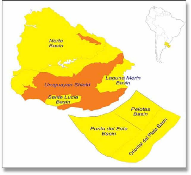
URUGUAY: SEDIMENTARY BASINS
Globalshift.co.uk (source: GEO ExPro)
Geology and History of Exploration
Uruguay is underlain by a Precambrian shield which is part of the Río de la Plata craton; an extensive area of stable crystalline basement that spreads across Uruguay and large areas of eastern Argentina and southern Brazil. In the north the shield is covered by younger volcanic rocks and sediments deposited during the initial opening of the South Atlantic up to Cretaceous time.
Onshore - Two sedimentary basins are recognised onshore; the Norte Basin and the Santa Lucia basin. The Norte Basin is a sub-basin of the Parana Basin, a large intra-cratonic area which extends over the north of Uruguay, the south of Brazil, the northeast of Argentina and the south of Paraguay.
It has an early Devonian to Late Cretaceous fill of shales, siltstones, sandstones and volcanics. A number of wells were drilled in the basin in the mid-1950s and mid-1980s but there appears to be no conventional petroleum potential. However, some shale oil potential may be present in the Permian Mungrullo Formation especially near the Brazilian border as determined by several hundred shallow wells drilled in the 1970s and 1980s.
The Santa Lucia Basin is an intra-cratonic basin, pull-apart basin which developed during the Jurassic and Cretaceous in the south of the country. It primarily contains sandstones and volcanics and Globalshift believes it is unlikely to contain viable source rocks.
Offshore - In the offshore waters of Uruguay sedimentation within the Atlantic rift system has continued through to the present day. Three basins are recognized (Punta del Este, Pelotas and the Oriental del Plata)created during the break-up of Gondwana and opening of the Atlantic Ocean. The Punta del Este Basin in the west is an aborted rift, perpendicular to the continental margin. The Pelotas Basin in the east is the flexural border of the south Atlantic rift. Since the Palaeocene both basins have developed as one. The Oriental del Plata Basin in the south underlies ultra-deep waters over a basement of transitional and oceanic crust.
The stratigraphy of these basins includes a syn-rift sequence (Jurassic-Neocomian) of aluvio-fluvial and lacustrine deposits, interbedded with volcanics; a post-rift sequence of transitional transgressive marine sediments (Barremian-Aptian) and regressive marine deposits (Late Cretaceous).
During the Cenozoic sedimentation continued to fluctuate in type as the sea level rose and fell. Source rocks may have matured in depocentres of the Cretaceous post-rift in the Punta del Este Basin and the Cenozoic post-rift in the Pelotas Basin.
History - Drilling in Uruguay began in 1954. Several dry wells were completed in the onshore Norte Basin up to 1958 followed by a long period of inactivity. From 1985 to 1987 five further wells were drilled but with no success. A number of stratigraphic wells have been drilled more recently in addition to some shallow tests for shale oil. Onshore licensing operates as an open door system.
Only 3 offshore exploratory wells have been drilled. The first two were drilled in 1976 in shallow waters of the Punta Del Este basin. The first offshore licensing round was held in 2009 (Uruguay Round 1 2009). Eleven blocks were available but only 2 were awarded with no well commitments (Areas 3 and 4) both to YPF. Shell farmed-in to these blocks but later pulled out.
Uruguay Round 2 followed signature of contracts for Round 1 and completion of extensive multi-client geophysical surveys. The Round called for bids for 15 offshore areas in September 2011. Data on the blocks were sold by ANCAP who received 19 offers for eight of the 15 blocks offered, from 9 companies in March 2012. The awarded areas were located in all 3 offshore basins. Areas 6, 11 and 12 were awarded to BP, areas 8, 9 and 13 were awarded to BG, area 14 was awarded to Total and area 15 was awarded to Tullow. Commitments included a deep water exploration well to be drilled by Total in Block 14 and extensive seismic surveys over a 3-year period, with optional further periods.
BP later relinquished its areas but Total drilled its well (Raya-1) in 2016. It was a dry hole although it was notable as the deepest water well ever drilled. Uruguay Round 3 was launched in 2018 and an open offshore round followed in 2019 in which large areas from shallow to ultra-deepwaters were available.